随着低空经济的快速发展, 低空、低速、小型无人机的非法飞行风险持续增加安徽利旺的低空目标识别系统, 以其权威感知, 智能识别, 精准应对和全面控制的核心功能,构建了集成的低空安全保护系统,为关键区域建立了坚实的低空安全屏障.
- 综合感知与监控:对低空情况的无障碍控制
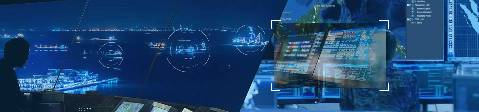
该系统的实时情况模块就像一个“长距离眼睛”,能够在整个区域进行无盲点的检测,相关数据在大屏幕上集中显示.
该模块专注于日常监控和异常分析.左侧清楚地显示了设备的数量和实时警告的类型,而右侧有一个视频窗口.它还使用折线图和饼图直观地呈现警告数量的趋势,使维修人员能够掌握低空安全的动态.
操作方便灵活.左侧侧栏中的工具箱支持切换地图类型、调整场景模式和设置自定义标签等功能.可以通过滚动鼠标来放大和缩小地图.它还内置了常见的地图测量工具, 如距离测量和面积测量, 以满足各种场景需求.
视频窗口可以通过拖动左下角自由调整大小.下面的警告信息窗口实时更新, 同步显示雷达和光电设备信息.定位功能允许用户直接在地图上查看设备的安装位置,实现设备状态的可视化管理.

- 智能识别与跟踪:准确区分目标,不偏移
该系统拥有强大的智能识别和跟踪能力.切换地图到高德地图后, 右键点击光电传感器图标, 选择可见光即可查看实时光电传感器视频.光电传感器的覆盖区域用阴影圆圈标记, 并用长线指示观察方向, 确保精确定位.
Durch Anklicken eines vom Radar erfassten Ziels werden sofort wichtige Informationen wie Zieltyp, Geschwindigkeit, Flughöhe, Breitengrad und Längengrad angezeigt. Nach Auswahl der KI-Erkennungsfunktion verfolgt die Kamera das Drohnenziel automatisch und liefert dabei klare Videoaufnahmen und eine flüssige Zielverfolgung.
Das System ist hinsichtlich seiner Leistung herausragend. Bei kleinen Drehflüglerdrohnen mit einem Radarquerschnitt (RCS) von nur 0,01 Quadratmetern (wie beispielsweise der DJI AI22S) erreichte das Radar im Chaohu-Experiment eine maximale Erfassungsreichweite von 9 Kilometern. Der KI-Algorithmus in Kombination mit der Spektrumanalyse kann über 300 Drohnenmodelle identifizieren und durch Merkmalsextraktion und intelligenten Vergleich Drohnen effektiv von Störsignalen wie Vögeln und Laub unterscheiden, wodurch Fehlinterpretationen vermieden werden.
In verschiedenen Tests arbeitete das System stabil und zuverlässig: Beim Test am Taihu-See in Suzhou begann das Radar die Detektion in 6 Kilometern Entfernung und fusionierte die RID-Daten in 4 Kilometern Entfernung. Das radargestützte fotoelektrische System begann in etwa 4 Kilometern Entfernung aus einem unscharfen Zustand mit der stabilen Verfolgung.
In Vergleichstests im Stadtgebiet von Suzhou, bei denen Drohnen auf Sperrlisten und Zulassungslisten sowie unbekannte Renndrohnenmodelle getestet wurden, erfasste das Radar Drohnen in einer Entfernung von 4 Kilometern, die fotoelektrische Verfolgung erfolgte in einer Entfernung von etwa 3 Kilometern und die RID-Daten wurden in einer Entfernung von 900 Metern fusioniert. Dies ermöglichte eine präzise Unterscheidung zwischen Drohnen auf Sperrlisten und Zulassungslisten und lieferte genaue Daten für die weitere Steuerung.
III. Flexible Frühwarnung und Reaktion: Schnelle und effiziente multidimensionale Reaktion
Das System unterstützt benutzerdefinierte Warn- und Gegenmaßnahmenzonen und ermöglicht so die flexible Festlegung von Schutzbereichen entsprechend den Sicherheitsanforderungen verschiedener Bereiche. Es wählt automatisch die optimale Reaktionsstrategie und gewährleistet damit ein personalisiertes Sicherheitsmanagement. Bei Erkennung eines Verstoßes benachrichtigt das System das Wartungspersonal umgehend über verschiedene Kanäle wie akustische und visuelle Alarme, Pop-up-Warnungen und SMS-Benachrichtigungen. Dies gewährleistet eine schnelle Reaktion und spart wertvolle Zeit bei der Bewältigung der Situation.
Die präzise Abstimmung zwischen Radar- und elektrooptischen Systemen ist ein wesentlicher Vorteil des Systems. Ihr Zusammenspiel erhöht die Effektivität der Tiefflugabwehr, lässt illegalen Drohnen keinen Raum zum Verstecken und schafft eine solide Grundlage für die Umsetzung nachfolgender Gegenmaßnahmen.
- Vielfältige und präzise Gegenmaßnahmen: Illegale Ziele sicher und effizient abfangen
Im Hinblick auf Gegenmaßnahmen bietet das System vielfältige Lösungen, die Effizienz und Sicherheit in Einklang bringen. Einerseits kann es Gegenmaßnahmengeräte integrieren und mit verschiedenen Geräten wie Radar-, fotoelektrischen und Spektrumsensoren zusammenarbeiten, um sich mit einem Spektrum-Gegenmaßnahmensystem zu verbinden, was ein rechtzeitiges Abfangen illegaler Ziele und eine schnelle Beseitigung von Sicherheitsrisiken ermöglicht;
Andererseits wurde eine sicherere Gegenmaßnahme eingeführt. Durch die Installation eines Fangnetzwerfers an der Drohne kann das System die Zieldrohne präzise lenken, erfassen und einfangen, wodurch die sekundären Risiken herkömmlicher Gegenmaßnahmen vermieden werden.
Mit der rasanten Entwicklung der Wirtschaft im Tiefflugbereich steigt auch das Risiko illegaler Flüge durch langsam fliegende, kleine Drohnen stetig an. Dies unterstreicht den zunehmenden Druck auf die Sicherheit im Tiefflugbereich, insbesondere in Schlüsselzonen wie Flugverbotszonen an Flughäfen und Militärbasen. Das Tiefflug-Zielidentifizierungssystem von Anhui Liaowang, das sich durch zuverlässige Erfassung, intelligente Identifizierung, präzise Gegenmaßnahmen und umfassende Kontrolle auszeichnet, bildet ein integriertes Sicherheitsschutzsystem für den Tiefflugbereich und schafft so eine solide Sicherheitsbarriere für Schlüsselzonen.
- Umfassende Wahrnehmung und Überwachung: Uneingeschränkte Kontrolle der Situation in niedrigen Höhen
Das Echtzeit-Situationsmodul des Systems fungiert wie ein „Fernsichtauge“, das eine lückenlose Erfassung des gesamten Bereichs ermöglicht, und die relevanten Daten werden zentral auf einem großen Bildschirm angezeigt.
Das Modul konzentriert sich auf die tägliche Überwachung und Anomalieanalyse. Auf der linken Seite werden übersichtlich die Anzahl der Geräte und die Art der Echtzeitwarnungen angezeigt, während sich auf der rechten Seite ein Videofenster befindet. Liniendiagramme und Kreisdiagramme veranschaulichen den Trend der Warnzahlen und ermöglichen es dem Wartungspersonal, die Dynamik der Sicherheit im Niedrigflugbereich stets im Blick zu behalten.
Die Bedienung ist komfortabel und flexibel. Die Werkzeugleiste in der linken Seitenleiste bietet Funktionen wie das Umschalten von Kartentypen, das Anpassen von Szenenmodi und das Festlegen benutzerdefinierter Beschriftungen. Die Karte lässt sich per Mausrad vergrößern und verkleinern. Zudem verfügt sie über gängige Vermessungswerkzeuge wie Entfernungs- und Flächenmessung, um unterschiedlichsten Anwendungsfällen gerecht zu werden.
Das Videofenster lässt sich durch Ziehen der unteren linken Ecke frei in der Größe anpassen. Das darunterliegende Warninformationsfenster wird in Echtzeit aktualisiert und zeigt synchron Informationen zu Radar- und optoelektronischen Geräten an. Die Positionsbestimmungsfunktion ermöglicht es dem Benutzer, den Installationsort der Geräte direkt auf der Karte anzuzeigen und so den Gerätestatus visuell zu verwalten.
- Intelligente Erkennung und Verfolgung: Unterscheidet Ziele präzise und ohne Abweichung.
Das System verfügt über leistungsstarke intelligente Erkennungs- und Verfolgungsfunktionen. Nach dem Wechsel zur Amap-Karte klicken Sie mit der rechten Maustaste auf das Symbol des Lichtsensors und wählen „Sichtbares Licht“, um das Echtzeit-Video des Lichtsensors anzuzeigen. Der Erfassungsbereich des Lichtsensors ist durch einen schattierten Kreis markiert, die Beobachtungsrichtung durch eine lange Linie, was eine präzise Positionierung gewährleistet.
Durch Anklicken eines vom Radar erfassten Ziels werden sofort wichtige Informationen wie Zieltyp, Geschwindigkeit, Flughöhe, Breitengrad und Längengrad angezeigt. Nach Auswahl der KI-Erkennungsfunktion verfolgt die Kamera das Drohnenziel automatisch und liefert dabei klare Videoaufnahmen und eine flüssige Zielverfolgung.
Das System ist hinsichtlich seiner Leistung herausragend. Bei kleinen Drehflüglerdrohnen mit einem Radarquerschnitt (RCS) von nur 0,01 Quadratmetern (wie beispielsweise der DJI AI22S) erreichte das Radar im Chaohu-Experiment eine maximale Erfassungsreichweite von 9 Kilometern. Der KI-Algorithmus in Kombination mit der Spektrumanalyse kann über 300 Drohnenmodelle identifizieren und durch Merkmalsextraktion und intelligenten Vergleich Drohnen effektiv von Störsignalen wie Vögeln und Laub unterscheiden, wodurch Fehlinterpretationen vermieden werden.
In verschiedenen Tests arbeitete das System stabil und zuverlässig: Beim Test am Taihu-See in Suzhou begann das Radar die Detektion in 6 Kilometern Entfernung und fusionierte die RID-Daten in 4 Kilometern Entfernung. Das radargestützte fotoelektrische System begann in etwa 4 Kilometern Entfernung aus einem unscharfen Zustand mit der stabilen Verfolgung.
In Vergleichstests im Stadtgebiet von Suzhou, bei denen Drohnen auf Sperrlisten und Zulassungslisten sowie unbekannte Renndrohnenmodelle getestet wurden, erfasste das Radar Drohnen in einer Entfernung von 4 Kilometern, die fotoelektrische Verfolgung erfolgte in einer Entfernung von etwa 3 Kilometern und die RID-Daten wurden in einer Entfernung von 900 Metern fusioniert. Dies ermöglichte eine präzise Unterscheidung zwischen Drohnen auf Sperrlisten und Zulassungslisten und lieferte genaue Daten für die weitere Steuerung.
III. Flexible Frühwarnung und Reaktion: Schnelle und effiziente multidimensionale Reaktion
Das System unterstützt benutzerdefinierte Warn- und Gegenmaßnahmenzonen und ermöglicht so die flexible Festlegung von Schutzbereichen entsprechend den Sicherheitsanforderungen verschiedener Bereiche. Es wählt automatisch die optimale Reaktionsstrategie und gewährleistet damit ein personalisiertes Sicherheitsmanagement. Bei Erkennung eines Verstoßes benachrichtigt das System das Wartungspersonal umgehend über verschiedene Kanäle wie akustische und visuelle Alarme, Pop-up-Warnungen und SMS-Benachrichtigungen. Dies gewährleistet eine schnelle Reaktion und spart wertvolle Zeit bei der Bewältigung der Situation.
Die präzise Abstimmung zwischen Radar- und elektrooptischen Systemen ist ein wesentlicher Vorteil des Systems. Ihr Zusammenspiel erhöht die Effektivität der Tiefflugabwehr, lässt illegalen Drohnen keinen Raum zum Verstecken und schafft eine solide Grundlage für die Umsetzung nachfolgender Gegenmaßnahmen.
- Vielfältige und präzise Gegenmaßnahmen: Illegale Ziele sicher und effizient abfangen

Im Hinblick auf Gegenmaßnahmen bietet das System vielfältige Lösungen, die Effizienz und Sicherheit in Einklang bringen. Einerseits kann es Gegenmaßnahmengeräte integrieren und mit verschiedenen Geräten wie Radar-, fotoelektrischen und Spektrumsensoren zusammenarbeiten, um sich mit einem Spektrum-Gegenmaßnahmensystem zu verbinden, was ein rechtzeitiges Abfangen illegaler Ziele und eine schnelle Beseitigung von Sicherheitsrisiken ermöglicht;
另一方面,引入了一种更安全的应对方法.通过在无人机上安装捕获网发射器,系统可以准确引导目标无人机锁定并捕获它,避免传统应对措施可能带来的二次风险.
安徽妙王科技有限公司为客户提供定制解决方案, 利用先进的设备性能、丰富的项目经验和全面的支持系统.未来我公司将继续专注于低空安全技术的创新, 保障低空经济的健康发展, 并为更安全, 更有序的低空环境做出贡献.
Mskyeye为客户提供定制解决方案,利用卓越的设备性能、丰富的项目经验和全面的支持系统.未来,我公司将继续专注于低空安全技术的创新, 保障低空经济的健康发展, 并为更安全, 更有序的低空环境做出贡献.